Majestic

Building 6 at the Maya ruins of Dzibanché, near Chetumal in Quintana Roo, México:

Majestic

Dzibanché is a bit of an odd duck — great things to see, but it’s sufficiently off the “usual” track for tourists that it doesn’t get many visitors. It doesn’t help, either, that basically all the tour guide books describe the road to the site as being a rutted dirt track (it’s narrow and crooked, but has been paved for at least 10 years).

Of course, the good news for those that *do* drive out to Dzibanché is that you’ll most likely have the place to yourself. Oh, and you can climb most of the pyramids here (unlike many of the more-visited ruins).

Building 6, by the way, is the first pyramid you see on your walk into the site. It’s also known as the “Palace of the Lintels” after some carved wood beams that were discovered here (sadly, they’ve been removed and replaced by more modern wood).

12 November update — by the way, if you happen to be planning a trip to the Yucatan, I’m in the process of releasing a set of 12 guides to Maya ruins. Oriented toward photography in the ruins, they only cost a couple of dollars each via Amazon’s Kindle store — the one for Dzibanché and its neighbors is described here. I’ve released two guides so far, the rest of the dozen should be out before the end of the year — so stay tuned!

Mesa Arch sunrise

So we recently returned home from an extended weekend trip to Moab, Utah and the surrounding area. If you’re unfamiliar with the neighborhood, “surroundings” in this case means Arches and Canyonlands National Parks.

Anyway, it’s been aeons since we last visited Moab — well before I had any decent digital camera gear, so I did my now-usual photographic research before we went. Turns out that one of the “must see” things in the area is sunrise at Mesa Arch in Canyonlands.

So here’s my first go at the sight (I’m still tweaking levels to make it look less-obviously HDRed):

Mesa Arch sunrise

In retrospect, it’s kind of funny how most images of this particular sunrise location focus heavily on the arch — when, from my perspective at least, the arch is best used as a nice frame for the incredibly layered scenery on the other side of it.

By the way, the layers come courtesy of local coal-fired power plants. Coal exhaust haze: lousy for lungs, great for sunrise vistas.

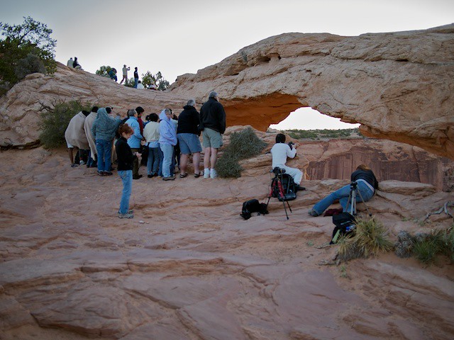
Anyway, from the looks of this, you can’t really tell just how small the arch is. Perhaps this helps:

2010-09-06 2010.09.06 Canyonlands sunrise crowd 7

Since the word is out about this arch, and there isn’t much room to set up in, you’re well advised to get there early (at least 45 minutes before sunrise) if you want a shot exactly at sunrise. At least, if you want to shoot over on the left side. Right side was less crowded the morning I went:

2010-09-06 2010.09.06 Canyonlands sunrise crowd 6

Go figure — the view’s just about as good from the less-crowded right side, too. FWIW, the tripod with the black and red leg padding (in line with the guy in white here) is my rig, firing away with an interval timer.

I scouted out the arch the day before in daylight and marked the parking lot on my GPS navigator — makes life a lot easier in the morning, when you’re driving in the dark with no visual cues. Oh, and bring a spelunker’s flashlight (the kind on an elastic band for your head) — makes it much easier to find the trail to the arch in the dark.

Getting to Antelope Canyon

If you’re at all into outdoor photography, you’ve likely seen shots from Antelope Canyon in Arizona — even if you didn’t know it at the time. This is the first in the series of posts I’ll be writing about a little detour we took to the canyon on a recent trip to see relatives in Arizona.

Antelope Canyon is actually a series of “slot canyons” in the drainages leading to Lake Powell in northern Arizona. Should you decide you want to see it, you’ll first have to get comfortable with a lot of driving, then you’ll have to decide which of two sections you’d like to see. Upper Antelope Canyon is somewhat more photogenic — but it’s been “discovered,” and so (I’ve heard) can be swamped by people being shuffled through it by the tightly-scheduled truckload.

Since ours was a family trip, we opted for Lower Antelope Canyon, instead. Much less crowded, not at all hectic, you can wander through at nearly your own pace (up to an hour as part of a “group,” up to 4 hours if you spend a few dollars extra for a “photographer pass”), and still very beautiful. Oh, and if you go this route, make sure to swing by an ATM first. When we went it cost $28 per adult and $16 per child (12-18), and payment is by cash only. We opted for a group outing (vs. photo pass) since I doubted our 8 year old would really be interested in spending 4 hours underground.

Anyway, when it comes to getting there, the biggest nearby city is Flagstaff — so let’s just say for the sake of argument that it’s your jumping-off point. From there, you drive about 2 hours north to an intersection just south of Page, then turn east on Highway 98. Once you pass the turnoff for Lechee, the road you want is the first left onto a paved drive, then take another left on a dirt road down to the parking lot. If you make it to one of the power plant roads (can’t miss this, it’s HUGE), you’ve gone too far and need to turn around.

Antelope Canyon from Page

Once you pay your fees, your guide takes you out to the entrance to the lower canyon, which is basically a hole in the ground — hardly looks wide enough from a distance, but it’s straightforward if you’re not carrying too much extra weight (either bodily, or in the form of camera gear).

Yes, there's an entrance here

This gal spoke German (and I only know a few words of it), but I have to think at the time she was saying something along the lines of “you’ve GOT to be kidding me!”

Access to this section of the canyon has improved dramatically since the addition of metal ladders bolted into the stone here and there. Mind you, some years back a group of people died here in a flash flood — it was raining far upstream, the local guides told them to get out, but the tourists’ stubbornness and the (then-used) rope ladders out combined to thwart their escape.

Anyway, if you’re reasonably good shape, you’ll have no problem getting down into the canyon (or out again). And make sure you pay attention to what the guides tell you to do.

Once you’re into the canyon, things get easier — more elbow room, although there are still some tight spots here and there. One thing you’ll need to contend with, though, is a wide range of lighting — something like a 10 stop difference between light and shadow. I’d recommend you do some multi-exposure HDR work if you want to wind up with a good shot — otherwise, you’ll have to content yourself with some really low contrast shots. This advice is particularly relevant if you get any sky in your image, like this one:

Looking up and out

This, BTW, is an HDR image (3 shots 1 stop apart, with a bit of noise cleanup afterward). More to come

Night along the trail

So let’s say you take a trip to Hawaii and manage to hike out to where the lava meets the sea. Pretty spectacular, particularly at night:

Pele's workshop

But of course, you hiked there in the dark (likely) over near-black lava (certainly), and now you need to get back to your car, in the dark. Makes for a pretty tough scene unless you brought a flashlight. Luckily, though, most folks remember this little item of equipment (although you’d be surprised how many show up unprepared)

Once you’re back at the trailhead, you can take a long-exposure shot of the folks behind you on the trail:

Night along the trail

If you’re having trouble visualizing what’s going on, here’s a VERY STRETCHED shorter exposure shot from the same spot:

EB256989

Note that all the ground below the horizon is solidified lava flows, the sky is only visible here because I took this on a cloudy night. I’m still amazed at how much detail is visible in this frame…

Rock crystal

A picture from the Hopewell Rocks, in Canada’s Bay of Fundy

Rock crystal

The Bay of Fundy has arguably the highest tides in the world, about 17 meters — the result of an odd resonance in the bay (a wave will travel from the mouth of the bay to the inner shore and back again in about the same time as the spacing between high tides). One of the offshoots of these tides is that a lot of ground gets uncovered at low tide.

Here, you see my daughter (just turned 7 when this picture was taken) standing under the middle of “Lovers Arch.” Come back in 12 hours, and only the green top of the arch will still be above water.